gEOGRAPHIC INFORMATION SYSTEMS (GIS)
 All organizations need to find the location and characteristics of their markets to help move their agenda forward. It could be; a promotion to find customers, a campaign to influence public opinion, a need to map your resources for a crisis, a need to optimize routing services, identify a flood plane, or a desire to know the spatial characteristics of your market to move in a new direction.
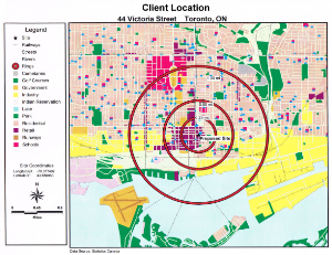
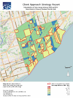
A geographic information system (GIS) is a system designed to capture, store, manipulate, analyze, manage, and present all types of geographic data GIS can be thought of as a system that provides spatial data, management, retrieval, analysis, and visualization functions. A GIS integrates, stores, edits, analyzes, shares, and displays geographic information for informing decision making.
A GIS helps an organization to analyze and map information. It allows you to maximize your influence and increase your market. The Geographic side of Group GIS is headed by Mark Baker who can find out and map a solution to your spatial problems or chart a path to new opportunities.
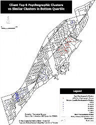 A GIS consists of three important components; data, modelling and analysis. If you don’t already have the data, Group GIS will source the data you need. Then we will work with you to build a model that fits your needs and structure it visually to help you identify patterns that you require for strategic decisions.